
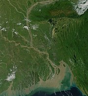


Bangladesh is in the low-lying Ganges-Brahmaputra River Delta or Ganges Delta. This delta is formed by the confluence of the Ganges (local name Padma or Pôdda), Brahmaputra (Jamuna or Jomuna), and Meghna rivers and their respective tributaries. The Ganges unites with the Jamuna (main channel of the Brahmaputra) and later joins the Meghna to eventually empty into the Bay of Bengal. The alluvial soil deposited by these rivers has created some of the most fertile plains in the world. Bangladesh has 58 trans-boundary rivers, making water issues politically complicated to resolve - in most cases as the lower riparian state to India. Most parts of Bangladesh are less than 12 metres (39 ft) above the sea level, and it is believed that about 50% of the land would be flooded if the sea level were to rise by a metre (3 ft).
The highest point in Bangladesh is in Mowdok range at 1,052 metres (3,451 ft) in the Chittagong Hill Tracts to the southeast of the country. A major part of the coastline comprises a marshy jungle, the Sundarbans, the largest mangrove forest in the world and home to diverse flora and fauna, including the Royal Bengal Tiger. In 1997, this region was declared endangered.
Straddling the Tropic of Cancer, Bangladeshi climate is tropical with a mild winter from October to March, a hot, humid summer from March to June. A warm and humid monsoon season lasts from June to October and supplies most of the country's rainfall. Natural calamities, such as floods, tropical cyclones, tornadoes, and tidal bores occur almost every year, combined with the effects of deforestation, soil degradation and erosion. Cox's Bazar, south of the city of Chittagong, has a beach that stretches uninterrupted over 120 kilometres (75 mi).
In September 1998, Bangladesh saw the most severe flooding in modern world history. As the Brahmaputra, Ganges and Meghna spilt over and swallowed 300,000 houses, 9,700 kilometres (6,000 mi) of road and 2,700 kilometres (1,700 mi) of embankment 1,000 people were killed and 30 million more were made homeless with 135,000 cattle killed, 50 square kilometres of land destroyed and 11,000 kilometres of roads damaged or destroyed. Two-thirds of the country was underwater. There were several reasons for the severity of the flooding. Firstly, there were unusually high monsoon rains. Secondly, the Himalayas shed off an equally unusually high amount of melt water that year. Trees that usually intercept rain water were cut down for firewood or to make space for animals.
Bangladesh is now widely recognized to be one of the countries most vulnerable to climate change. Natural hazards that come from increased rainfall, rising sea levels, and tropical cyclones are expected to increase as climate change, each seriously affecting agriculture, water & food security, human health and shelter. It is believed that in the coming decades the rising sea level alone will create more than 25 million climate refugees.
.jpg)